


Archiu:Venice Lagoon December 9 2001.jpg
Tamany d'esta vista prèvia: 512 × 599 píxels. Atres/s resolucions: 205 × 240 píxels | 410 × 480 píxels | 656 × 768 píxels | 875 × 1024 píxels | 1750 × 2048 píxels | 3580 × 4189 píxels.
Resolució completa. ((3580 × 4189 pixels, tamany de l'archiu: 11,35 MB, MIME tipo: image/jpeg))
Summary
| Description |
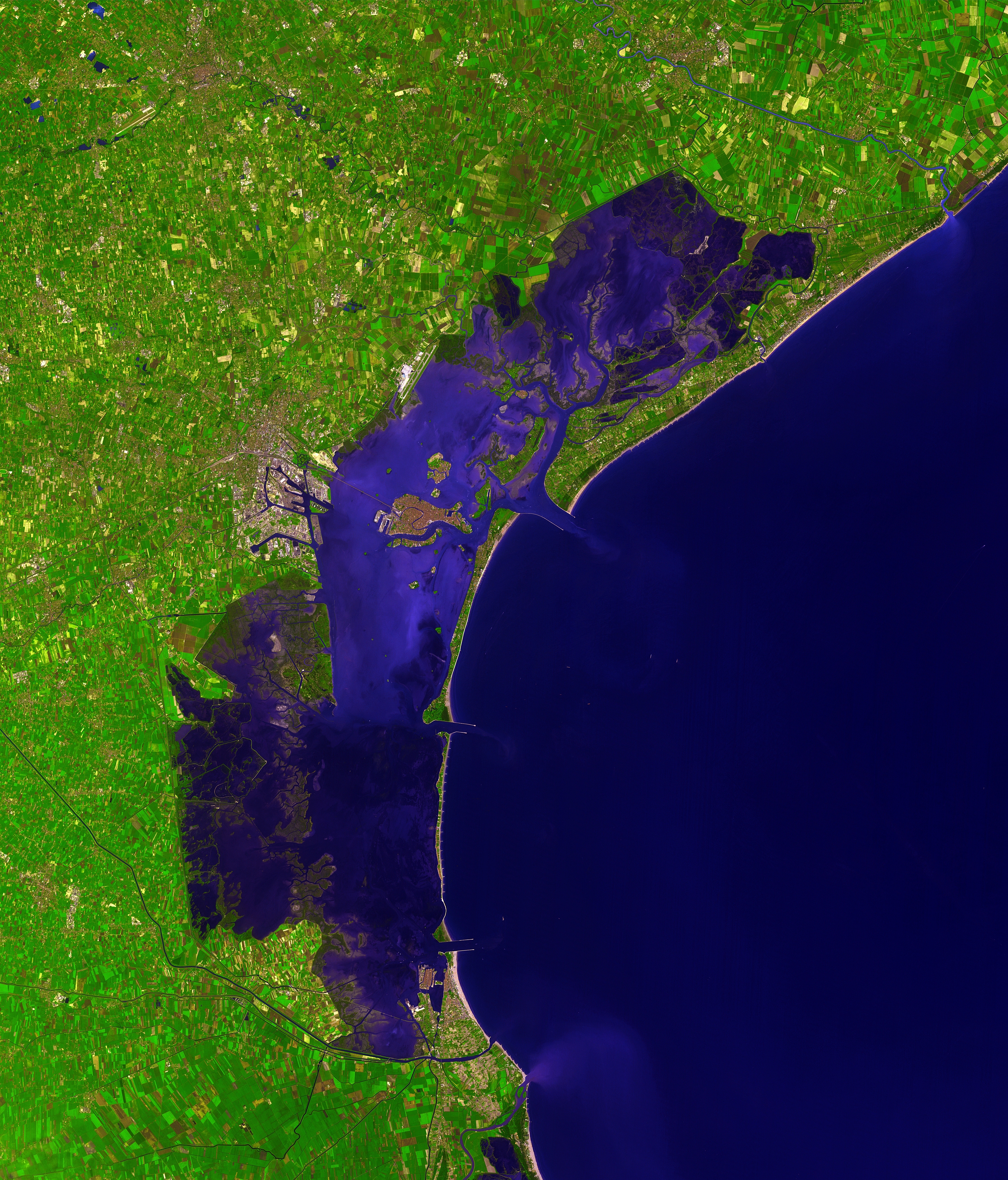
Deutsch: Dieses Satellitenbild der Lagune von Venedig wurde von ASTER (Advanced Spaceborne Thermal Emission and Reflection Radiometer) aufgenommen, einem Aufnahmesystem an Bord des Satelliten Terra der Teil des NASA Earth Observing System (EOS) ist. Das Bild wurde am 9. Dezember 2001 erstellt und deckt eine Fläche von 39 x 35 km ab. (Simulierte Naturfarben)
English: This picture of the Venetian Lagoon was taken by ASTER (Advanced Spaceborne Thermal Emission and Reflection Radiometer), an imaging instrument flying on Terra, a satellite part of NASA's Earth Observing System (EOS). It covers an area of 39 x 35 km and was acquired on December 9, 2001. (simulated natural color)
Français : Image de la lagune de Venise prise par l'instrument d'imagerie ASTER (Advanced Spaceborne Thermal Emission and Reflection Radiometer) embarqué sur le satellite Terra, lancé dans le cadre du programme EOS (Earth Observing System, ou Système d'Observation de la Terre). Aire couverte: 39 x 35 km, Couleurs naturelles simulées. Image prise le 9 décembre 2001.
Italiano: Questa immagine della Laguna di Venezia è stata ripresa da ASTER (Advanced Spaceborne Thermal Emission and Reflection Radiometer), uno strumento installato su Terra, un satellite della NASA Earth Observing System (EOS). Copre un'area di 39 x 35 km ed è stata ripresa il 9 dicembre 2001. (colori naturali simulati) |
| Date | |
| Source | http://earthobservatory.nasa.gov/Newsroom/NewImages/images.php3?img_id=16314 |
| Author | NASA/GSFC/MITI/ERSDAC/JAROS, and U.S./Japan ASTER Science Team |
| Other versions |
 |
| Camera location |  | View this and other nearby images on: OpenStreetMap |  |
|---|
|


|
This image was selected as picture of the day on Wikimedia Commons for 15 September 2007. It was captioned as follows: English: Satellite photo of the Venetian Lagoon. Other languages:
Asturianu: Semeya satelital de la Llaguna de Venecia Deutsch: Satellitenbild der Lagune von Venedig English: Satellite photo of the Venetian Lagoon. Español: Fotografía de satélite de la laguna de Venecia. Euskara: Veneziako badia satelitetik ikusia Français : La lagune de Venise vue par satellite Íslenska: Gervihnattamynd af Feneyjalóni. Italiano: Foto satellitare della laguna di Venezia. Magyar: A velencei lagúna műholdas képe (39 x 35 km-es terület, szinezve, 2001. december 9.) Беларуская: Венецыянская лагуна, здымак з космасу. Русский: Венецианская лагуна, снимок из космоса |
Licensing

|
This file is in the public domain in the United States because it was solely created by NASA. NASA copyright policy states that "NASA material is not protected by copyright unless noted". (See Template:PD-USGov, NASA copyright policy page or JPL Image Use Policy.) |  |
 |
Warnings:
|
| Annotations | This image is annotated: View the annotations at Commons |




Historial de l'image
Puncha en la data/hora per a vore l'image tal i com es mostrava en eixe moment.
| Data/Hora | Miniatura | Dimensions | Usuari | Descripció | |
|---|---|---|---|---|---|
| actual | 15:41 7 dec 2006 | | 3580 × 4189 (11,35 MB) | wikimediacommons>AlMare | Cropped |
Enllaços a l'image
Les següents pàgines enllacen ad esta image:
