


Archiu:Indo-European branches map.png


|
File:Indo-European branches map.svg is a vector version of this file. It should be used in place of this PNG file when not inferior.
File:Indo-European branches map.png → File:Indo-European branches map.svg
For more information, see Help:SVG. |
 |
 Any autoconfirmed user can overwrite this file from the same source. Please ensure that overwrites comply with the guideline.
Summary
| Description |
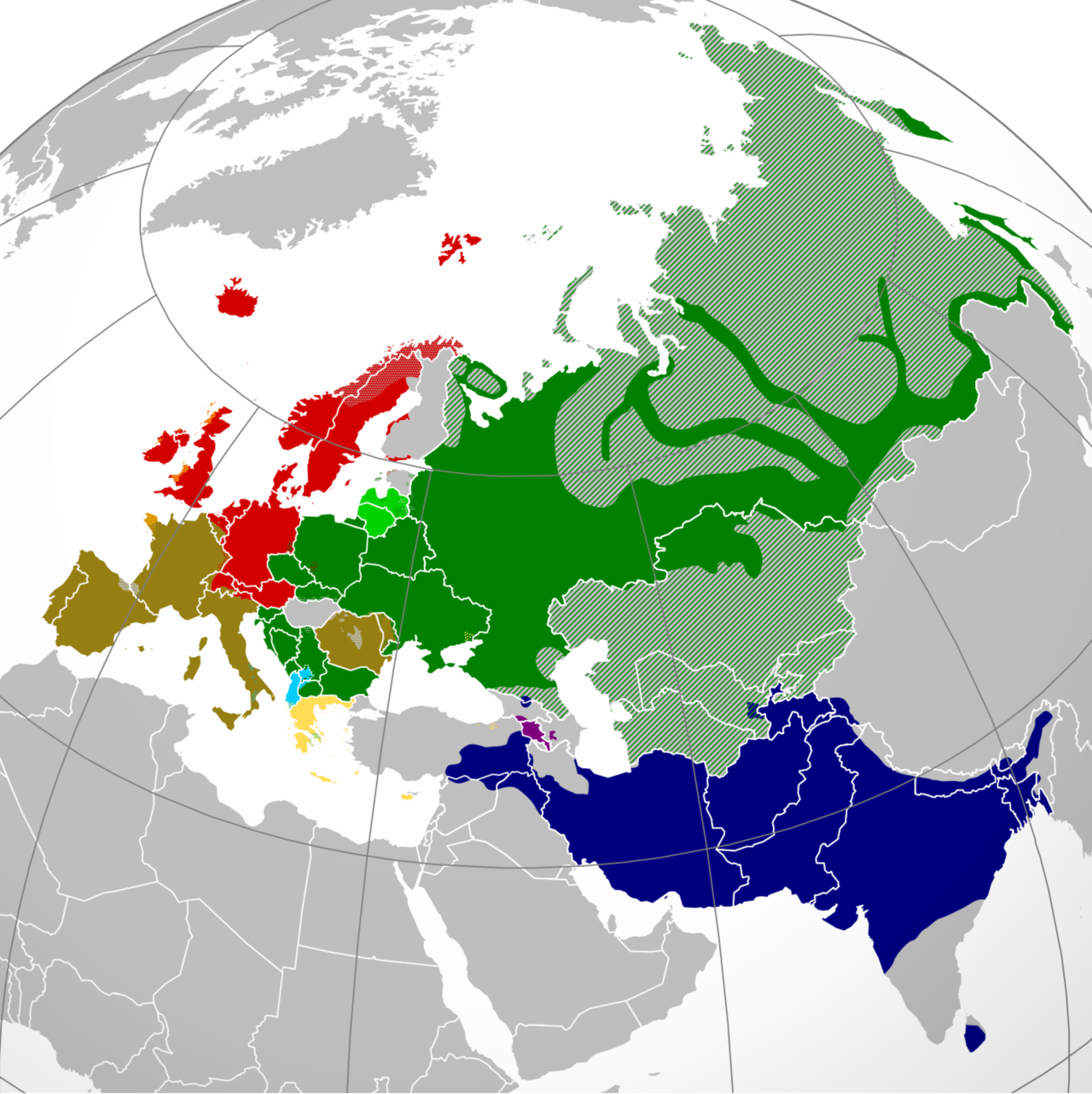
English: A map showing the approximate present-day distribution of the Indo-European branches within their homelands of Europe and Asia. The following legend is given in the chronological order of the earliest surviving written attestations of each branch:
Non-Indo-European languages
Dotted/striped areas indicate where multilingualism is common (more visible upon full enlargement of the map). |
||
| Date | |||
| Source |
For the names of the branches, see citations in legend (based on "Indo-European Languages". The College of Liberal Arts. UT Austin. 2008.) and "Indo-European languages" from Britannica.com. The distribution is essentially and approximately based on the map "Indo-European languages – Approximate locations of Indo-European languages in contemporary Eurasia" from Britannica.com, although with the following minor modifications: The two articles "Balto-Slavic languages" and "Indo-Iranian languages" from Britannica.com stress the lack of scholarly consensus on these branches. That is, for the former, whether Baltic and Slavic developed from a common ancestral language, or that the similarities are the result of parallel development and of mutual influence during a long period of contact. To cater for both scholarly viewpoints, this map shows Baltic and Slavic with two distinct shades of green under "Balto-Slavic". For the latter, the dispute is whether the Indo-Iranian languages include just the Iranian and Indo-Aryan (or, Indic) language groups, or Nūristānī and Bangani too. To prevent disagreement (and also because this map only represents the primary branches of Indo-European), all of Indo-Iranian is represented with one shade. The article "Romance languages" from Britannica.com states that the Romance languages form "a subgroup of the Italic branch of the Indo-European language family". It should be noted that this map is only approximative and simplified, and glosses over some multilingual areas (particularly in eastern Russia, which is difficult to represent accurately). For some areas, more regional maps have been used as sources for greater accuracy, namely "Languages of Switzerland" from Ethnologue.com, "Russia ethnic plurality" from Freelang.net, "Major ethnic groups in Central Asia" from Globalsecurity.org, and "South Asian Language Families" from "Language families and branches, languages and dialects in A Historical Atlas of South Asia". Oxford University Press. New York 1992. |
||
| Author | Hayden120 | ||
| Permission (Reusing this file) |
I, the copyright holder of this work, hereby publish it under the following licenses:    This file is licensed under the Creative Commons Attribution-Share Alike 3.0 Unported, 2.5 Generic, 2.0 Generic and 1.0 Generic license.
You may select the license of your choice. |







Historial de l'image
Puncha en la data/hora per a vore l'image tal i com es mostrava en eixe moment.
| Data/Hora | Miniatura | Dimensions | Usuari | Descripció | |
|---|---|---|---|---|---|
| actual | 21:50 26 jun 2026 | | 2934 × 2938 (1,52 MB) | wikimediacommons>Monoxyde | optimize file size (pngout -k1 -f5 -b750) |
Enllaços a l'image
Les següents pàgines enllacen ad esta image:
