


Archiu:Gonâve microplate.png

Tamany d'esta vista prèvia: 800 × 506 píxels. Atres/s resolucions: 320 × 202 píxels | 640 × 405 píxels | 1024 × 647 píxels | 1280 × 809 píxels | 2115 × 1337 píxels.


Resolució completa. ((2115 × 1337 pixels, tamany de l'archiu: 1,3 MB, MIME tipo: image/png))

| Description |
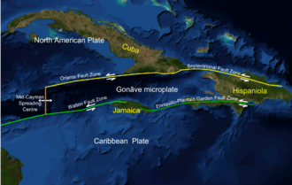
English: Screen shot from Nasa WorldWind software of NW Caribbean area |
| Date | (UTC) |
| Source | |
| Author |
|
 |
This is a retouched picture, which means that it has been digitally altered from its original version. Modifications: Added plate boundaries and main faults, island names and plate names. The original can be viewed here: NWCaribbean satellite.png:  . Modifications made by Mikenorton. . Modifications made by Mikenorton.
|
 |
This image is in the public domain because it is a screenshot from NASA’s globe software World Wind using a public domain layer, such as Blue Marble, MODIS, Landsat, SRTM, USGS or GLOBE.
|
 |
Original upload log
This image is a derivative work of the following images:
- File:NWCaribbean_satellite.png licensed with PD-WorldWind
- 2010-02-07T16:43:33Z Mikenorton 2111x1337 (1221182 Bytes) {{Information |Description={{en|1=Screen shot from Nasa WorldWind software of NW Caribbean area}} |Source=NASA WorldWind |Author=Mikenorton |Date=2010-02-07 |Permission={{PD-WorldWind}} |other_versions= }} [[Category:Satelli
Uploaded with derivativeFX
Historial de l'image
Puncha en la data/hora per a vore l'image tal i com es mostrava en eixe moment.
| Data/Hora | Miniatura | Dimensions | Usuari | Descripció | |
|---|---|---|---|---|---|
| actual | 16:50 7 feb 2010 | | 2115 × 1337 (1,3 MB) | wikimediacommons>Mikenorton | {{Information |Description={{en|1=Screen shot from Nasa WorldWind software of NW Caribbean area}} |Source=*File:NWCaribbean_satellite.png |Date=2010-02-07 16:49 (UTC) |Author=*File:NWCaribbean_satellite.png: Mikenorton *derivative work: ~~~ |P |

Enllaços a l'image
Les següents pàgines enllacen ad esta image:
